
One Place for the Mountains
Introducing Hwy17.org
By Eric Horton
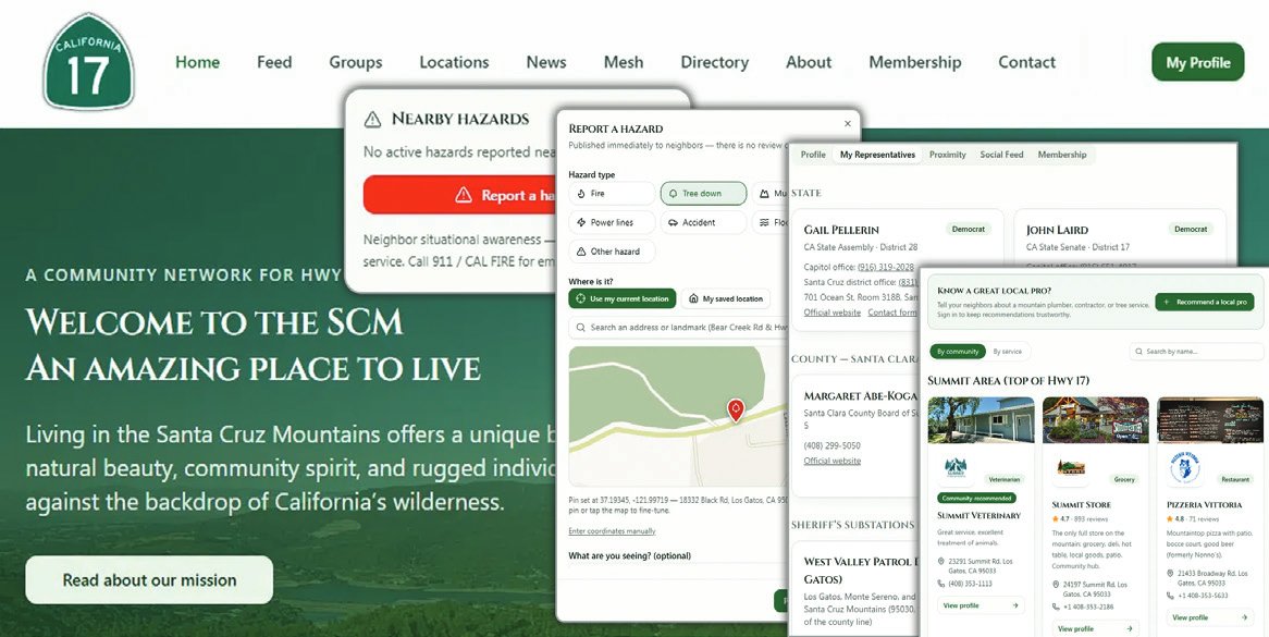
If you live in the mountains, you know the drill. A tree comes down across your road, and you piece together what happened from three Facebook groups, a text thread, and a neighbor at the mailbox. The power is out again, and you’re refreshing PG&E’s outage map while scrolling Nextdoor.
Do you need a good contractor? You’re back to asking around and hoping someone gives you a good referral. We are all used to this, but I don’t think we should be. That’s why I built Hwy17.org. Our communities aren’t short on ways to communicate. What we’re short on is a place where information stays organized, tied to where you live on the mountain. Hwy17.org covers the corridor communities between Los Gatos and Santa Cruz across our seven zip codes. Here’s what it offers.
Safety first. We may have a record-breaking El Niño winter. Members can report a downed tree, road closure, fire, mudslide, or washout, with photos and a precise map location. Neighbors can verify, update, or mark a hazard cleared, so information stays accurate as conditions change. A proximity view shows what’s near your address. A hazard alert strip on the home page is visible to everyone. Safety information shouldn’t sit behind a login wall.
Neighbors and groups. Set your zip code and you’re automatically joined to your neighborhood group, plus interest groups for hiking, gardening, parents, and more. Mountain recommendations. The mountain directory is searchable and filterable. Members can recommend contractors, tree crews, and other local professionals they trust. Submissions are moderated before publishing, so you get real recommendations, not search-engine noise.
News and civic basics. Read local news from multiple sources. Find out who your government representatives are based on your address, from your U.S. House district (including the tricky 95033 split between districts 18 and 19) down to your county supervisor. There are also zip-specific directories for your sheriff’s service center, fire stations, and emergency services, so the right phone numbers for your exact spot on the mountain are just a click away.
Off-grid communication, opened up to the rest of us. MeshCore radios pass messages across the mountains without cell towers or internet, but that world has belonged to people with the gear and the technical know-how. Hwy17.org puts the coverage map out where anyone can see it, radio or not. Own a device? Register your node and connect it through your browser.
If you don’t own a MeshCore radio, you can still watch the network take shape and decide whether it’s worth getting into. Actively moderated, on purpose. We all know what an unmoderated neighborhood feed turns into: the same handful of arguments, the pile-ons, the noise that drowns out anything useful. Hwy17.org is tended firmly. We ensure all accounts are authenticated, have clear community guidelines, and moderators who keep things civil and on-topic so the feed stays worth reading. This is a place to help your neighbors, not to fight with them.
Safety information stays free for everyone. Full member access costs $2 a month or $18 a year, which keeps this community- owned rather than dependent on selling your attention. No single feature here is unique. The value is the combination: one place, built for mountain living, owned by the community it serves. Come sign up, file that first hazard report when the rain starts, and tell me what’s missing. Find us at hwy17.org.